


‘FANI’ to intensify into very severe cyclonic storm by tomorrow night: IMD
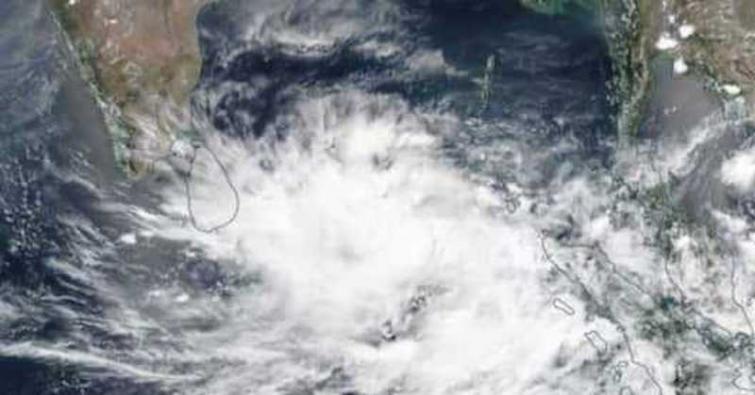
Hyderabad, Apr 28 (UNI): The Cyclonic Storm ‘FANI’ (pronounced as ‘FONI’) over southeast Bay of Bengal and neighbourhood moved northwestwards with a speed of about 10 kmph in last six hours and lay centred at 1430 hrs on Sunday near latitude 7.7°N and longitude 87.5°E over southeast Bay of Bengal & neighbourhood, about 690 km east-southeast of Trincomalee (Sri Lanka), 990 km southeast of Chennai (Tamil Nadu) and 1170 km south-southeast of Machilipatnam (Andhra Pradesh).
It is very likely to intensify into a Severe Cyclonic Storm during next06 hours and into a Very Severe Cyclonic Storm during subsequent 24 hours. It is very likely to move northwestwards till the evening of May 1 and thereafter recurve north-northeastwards gradually, India Meteorological Department (IMD) said in a bulletin.
Heavy rainfall warning:
Light to moderate rainfall at many places with heavy falls at isolated places is very likely over Kerala on April 29 and 30. Light to moderate rainfall at few places over North Coastal Tamil Nadu & South coastal Andhra Pradesh on Monday and Tuesday.
Light to moderate rainfall at few places very likely over North Coastal Andhra Pradesh & South coastal Odisha on May 2. It is likely to increase in intensity with heavy rainfall over coastal Odisha from May 3.
Wind warning:
Gale wind speed reaching 80-90 kmph gusting to 100 kmph is prevailing over Southeast Bay of Bengal & neighbourhood. It is very likely to increase gradually becoming 120-130 kmph gusting to 145 kmph over Southwest Bay of Bengal from April 29th night and 160-170 kmph gusting to 185 kmph over southwest & adjoining westcentral Bay of Bengal off north Tamil Nadu, Puducherry and South Andhra Pradesh Coasts from May 1st night. It is likely to become 150-160 kmph gusting to 175 kmph over westcentral Bay of Bengal off Andhra Pradesh Coast on May 3.
Strong wind speed reaching 30-40 kmph gusting to 50 kmph likely to commence along & off Tamil Nadu & Puducherry coast, Comorin area and Gulf of Mannar from this morning, becoming squally wind speed reaching 40-50 kmph gusting to 60 kmph from April 29th morning.
It is very likely to become squally wind speed reaching 50-60 kmph gusting to 70 kmph from April 30th morning along North Tamil Nadu, Puducherry and south Andhra Pradesh Coasts.
Strong wind speed reaching 30-40 kmph gusting to 50 kmph likely to commence along & off Kerala coast from this evening and becoming squally wind speed reaching 40-50 kmph gusting to 60 kmph tomorrow and day after tomorrow.
Squally wind speed reaching 40-50 kmph gusting to 60 kmph is very likely to commence along & off north Andhra Pradesh & Odisha Coasts from May 2nd and likely to become 50-60 kmph gusting to 70 kmph from May 3rd onwards over the same area.
Sea condition:
The sea condition is very high over Southeast Bay of Bengal & neighbourhood. It is very likely to become very high from today evening over the same area. It is likely to become phenomenal over southwest & adjoining westcentral Bay of Bengal, off north Tamil Nadu, Puducherry and south Andhra Pradesh Coasts from April 29th night and over westcentral Bay of Bengal off Andhra Pradesh Coast during May1-3.
Sea conditions very likely to be rough to very rough along & off Puducherry, Tamil Nadu and South Andhra Pradesh Coasts from April 29th to May 1, along & off north Andhra Pradesh Coasts from May1-3 and along & off Odisha Coast from May 2nd onwards.
Fishermen Warning:
The fishermen are advised not to venture into deep sea areas of Southeast Bay of Bengal and adjoining Equatorial Indian Ocean, over Southwest Bay of Bengal and off Sri Lanka coast today; Southwest and adjoining westcentral Bay of Bengal, along and off Sri Lanka, Puducherry, Tamil Nadu and south Andhra Pradesh Coasts from April 29th l to May 1, along and off westcentral Bay of Bengal, along and off North Andhra Pradesh Coast during May 1-3 and northwest & adjoining west]central Bay of Bengal along and off Odisha coast from May 2 onwards.
Those, who are out in deep sea above areas are advised return to the coasts, the bulletin said.
Image credit: UNI
Support Our Journalism
We cannot do without you.. your contribution supports unbiased journalism
IBNS is not driven by any ism- not wokeism, not racism, not skewed secularism, not hyper right-wing or left liberal ideals, nor by any hardline religious beliefs or hyper nationalism. We want to serve you good old objective news, as they are. We do not judge or preach. We let people decide for themselves. We only try to present factual and well-sourced news.
Support objective journalism for a small contribution.


